


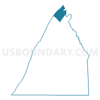
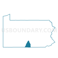
FANNETT TWP VTD CONCORD, Franklin County, Pennsylvania
About
Outline

Summary
| Unique Area Identifier | 659761 |
| Name | FANNETT TWP VTD CONCORD |
| County | Franklin County |
| State | Pennsylvania |
| Area (square miles) | 18.92 |
| Land Area (square miles) | 18.92 |
| Water Area (square miles) | 0.00 |
| % of Land Area | 99.99 |
| % of Water Area | 0.01 |
| Latitude of the Internal Point | 40.24118780 |
| Longtitude of the Internal Point | -77.68758420 |
Maps

Graphs
Select a template below for downloading or customizing gragh for FANNETT TWP VTD CONCORD, Franklin County, Pennsylvania


Neighbors
Neighoring Voting District (by Name) Neighboring Voting District on the Map
- FANNETT TWP VTD DRY RUN, Franklin County, PA
- FANNETT TWP VTD SULPHUR SPRINGS, Franklin County, PA
- LACK TWP VTD ROSS FARM, Juniata County, PA
- TELL TWP Voting District, Huntingdon County, PA
- TOBOYNE TWP DIST 01, Perry County, PA
- TOBOYNE TWP DIST 02, Perry County, PA
Top 10 Neighboring County Subdivision (by Population) Neighboring County Subdivision on the Map
- Fannett township, Franklin County, PA (2,548)
- Lack township, Juniata County, PA (785)
- Tell township, Huntingdon County, PA (662)
- Toboyne township, Perry County, PA (443)
Top 10 Neighboring Unified School District (by Population) Neighboring Unified School District on the Map
- Juniata County School District, PA (24,019)
- West Perry School District, PA (18,994)
- Southern Huntingdon County School District, PA (7,984)
- Fannett-Metal School District, PA (4,521)
Top 10 Neighboring State Legislative District Lower Chamber (by Population) Neighboring State Legislative District Lower Chamber on the Map
- State House District 86, PA (66,211)
- State House District 82, PA (64,036)
- State House District 81, PA (60,600)
Top 10 Neighboring State Legislative District Upper Chamber (by Population) Neighboring State Legislative District Upper Chamber on the Map
- State Senate District 33, PA (280,954)
- State Senate District 34, PA (268,795)
- State Senate District 30, PA (239,492)
Top 10 Neighboring 111th Congressional District (by Population) Neighboring 111th Congressional District on the Map
Top 10 Neighboring Census Tract (by Population) Neighboring Census Tract on the Map
- Census Tract 101, Franklin County, PA (4,414)
- Census Tract 306.02, Perry County, PA (3,038)
- Census Tract 9511, Huntingdon County, PA (2,057)
- Census Tract 702.01, Juniata County, PA (2,025)
Top 10 Neighboring 5-Digit ZIP Code Tabulation Area (by Population) Neighboring 5-Digit ZIP Code Tabulation Area on the Map
- 17021, PA (1,088)
- 17006, PA (1,052)
- 17213, PA (639)
- 17220, PA (534)
- 17219, PA (405)
- 17210, PA (193)
- 17217, PA (150)
- 17071, PA (108)